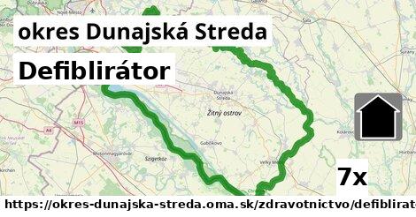
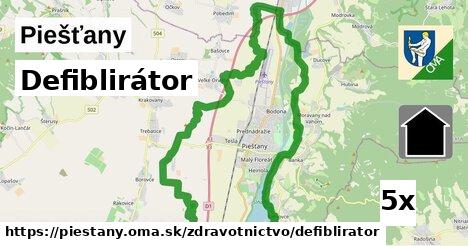
Defiblirátor, Trnavský kraj:, 1 z 2
defiblirátor, defiblirátor, defiblirátor, defiblirátor, defiblirátor, defiblirátor, defiblirátor, defiblirátor, defiblirátor, defiblirátor, defiblirátor, defiblirátor, defiblirátor, defiblirátor, defiblirátor, defiblirátorDefiblirátor, Trnavský kraj:, 2 z 2
defiblirátor, defiblirátor, defiblirátor, defiblirátor, defiblirátor, defiblirátor, defiblirátor, defiblirátor, defiblirátor, defiblirátor, defiblirátor, defiblirátor, defiblirátor, defiblirátor, defiblirátordefiblirátor inde
okres Piešťany (9x), okres Dunajská Streda (7x), Piešťany (5x), okres Senica (4x), okres Hlohovec (3x), okres Skalica (3x), okres Trnava (3x), okres Galanta (2x), Banka (2x), Hlohovec (2x), Sládkovičovo (1x), Kľačany (1x), Dolné Zelenice (1x), Koplotovce (1x), Dvorníky (1x), Pečeňady (1x), Vrbové (1x), Prašník (1x), Chtelnica (1x), Trnava (1x), Smolenice (1x), Horné Orešany (1x), Cerová (1x), Moravský Svätý Ján (1x), Prievaly (1x), Senica (1x), Sekule (1x), Cerová-Lieskové (1x), Kátov (1x), Prietržka (1x)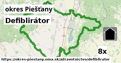
Podobné, Trnavský kraj:
158x lekáreň, 146x ordinácia, 53x zubár, 31x defiblirátor, 23x veterinár, 18x poliklinika, 8x nemocnica, 7x zdravotnícke pomôcky, 1x zhromaždiskoHľadáme defiblirator, OSM tagy: emergency = 'defibrillator'.

